
Breakfast in this shop in Mae Sariang - photo taken with the proprietor.
Day 11 (16.11.2012) Mae Sariang - a day trip to Mae Sam Laep (50km)
After a good pork and egg porridge breakfast in a shop opposite our Mit A Ree Hotel, we walked to the morning market and took the songthaew (B80pp) for a day trip to Mae Sam Laep, a river border village on the Thai side. The road journey took us 1.5 hrs on a dusty winding hilly road. The other side of the river is Myanmar.
We then hired a boat to take us upstream on the Salawin River for an hour which cost us B600 and if you wish to visit the village further up would be B1,300. We returned to Mae Sariang on the same songthaew at 12.30pm and took a rest before walking out at 4.30pm to the Museum and two temples. We were surprised that the beautiful museum building has nothing to display and not in used. We had dinner at Inthira Rastaurant again in Mae Sariang.
Sleeping: Mit A Ree Hotel at B400 a/c room for 2pax

After a good pork and egg porridge breakfast in a shop opposite our Mit A Ree Hotel, we walked to the morning market and took the songthaew (B80pp) for a day trip to Mae Sam Laep.

Mae Sariang is a small town alongside the Yuam River in Mae Hong Son Province, along the Myanmar border has many links to Burma, such as its architecture and a large population of Burmese Muslims.

We took this songthaew (B80pp) to Mae Sam Laep which was also loaded with groceries and hardware.

We took this songthaew (B80pp) to Mae Sam Laep which was also loaded with groceries and hardware.

Bernard Lee helped to unload some of the hardware to the villages along the road to Mae Sam Laep.

A simple bamboo house along the road to Mae Sam Laep.

The heavy traffic along the 50km hilly winding dirt road to Mae Sam Laep.

The 50km hilly winding dirt road to Mae Sam Laep, within the boundaries of Salawin National Park.

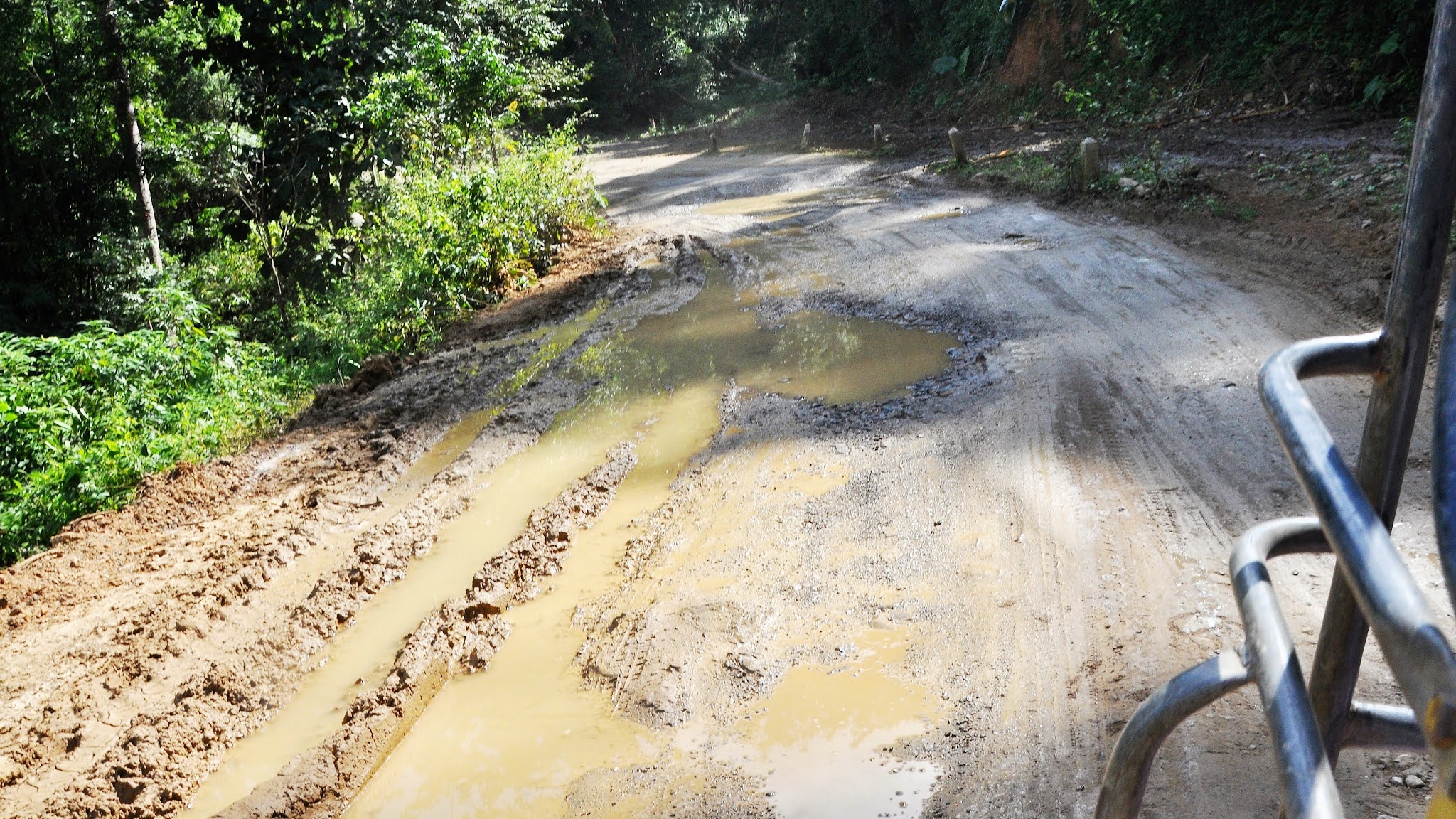
Many a time on wet muddy dirt road to Mae Sam Laep, within the boundaries of Salawin National Park.

Many a time on wet muddy dirt road to Mae Sam Laep, within the boundaries of Salawin National Park.

On dirt road to Mae Sam Laep, within the boundaries of Salawin National Park.

Many a time on wet muddy dirt road to Mae Sam Laep, within the boundaries of Salawin National Park.

On dirt road to Mae Sam Laep, within the boundaries of Salawin National Park.

Many a time on wet muddy dirt road to Mae Sam Laep, within the boundaries of Salawin National Park.

Passing by tribal Karen village houses dotting along the road up in the hill to Mae Sam Laep.

All the way down from a hill top on this dirt road to the border town of Mae Sam Laep.

Passing by tribal Karen village houses dotting along the mountainous and forested road to Mae Sam Laep.

Loading more passengers along the way to the border town of Mae Sam Laep.

A Burmese refugee woman along the way to the border town of Mae Sam Laep.

Burmese refugee houses along the road to the border town of Mae Sam Laep.

Burmese refugee houses along the road to the border town of Mae Sam Laep.

Burmese refugee bamboo huts with leaf roofs dot along the road to the border town of Mae Sam Laep.

Burmese refugee houses along the road to the border town of Mae Sam Laep.

Arrived at Mae Sam Laep a town of multi tribal ethnic cultures and life styles sitting on the bank of Salawin River opposite Myanmar's Kayin (Karen) state. Populated by refugees from Myanmar, the village has a raw, border-town feel.

A photo taken with a Burmese refugee family at Mae Sam Laep.

Mae Sam Leap lies near the Burmese border on the Salawin River - across the river is Burma.

Salawin River forming the 120km boundary between Burma and Thailand is about 2,815km long, that flows from the Tibetan Plateau into the Andaman Sea.

Bernard Lee registering our boat trip on the Salawin River to the Mae Sam Leap border police. The boat skipper is on the left.

Mae Sam Laep boat trips along the Mae Nam Salawin.

From the pier at Mae Sam Laep it’s possible to charter boats south to Sop Moei (approximately 2000B, 1½ hours), 25km from Mae Sam Laep, and north to the Salawin National Park station at Tha Ta Fang (approximately 1500B, one hour), 18km north of Mae Sam Laep.

Passenger boats at Mae Sam Laep, departures are infrequent unless you speak Thai.

Passenger boats at Mae Sam Laep, departures are infrequent unless you speak Thai.

Mae Sam Laep boat trips along Salawin River pass through untouched jungle, unusual rock formations and occasionally enter Myanmar.

Mae Sam Laep boat trips along Salawin River pass through untouched jungle, unusual rock formations and occasionally enter Myanmar.

Salawin River is too cold to swim in, it’s not the temperature but the very fast current.

An hour-long trip along Salawin River, with Burma on one side of us, and Thailand on the other.

An hour-long trip along Salawin River, with Burma on one side of us, and Thailand on the other.

The Salawin River water level is at its lowest at this time of the year - highest in June to August.

The Salawin River water level is at its lowest at this time of the year - highest in June to August.

There are many Thai soldiers patrolling along the Salawin River.

After a great Salawin River trip, we were back on the windy mountain roads to Mae Sariang.

After a great Salawin River trip, we were back on the windy mountain roads to Mae Sariang.

So many cows along Salawin River, we were back on the windy mountain roads to Mae Sariang.

Mae Sariang Museum at the intersection of Hwy 108 and Hwy 105, the museum is a single-storey raised wooden building in a design which blends traditional Thai Yai wood-carving with northern Thai architectural styles. However, there is nothing inside the building.

Mae Sariang Museum is noted for its ornate Burmese roof and is landmark in Mae Sariang, Mae Hong Son Province.

Wat Chong Sung is located in downtown Mae Sariang District of Mae Hong Son, next to Wat Si Bunruang with which it shares a door linking the two the temple together.

The wooden monastic buildings of Wat Jong Sung in Mae Sariang.

Wat Chong Sung is located in downtown Mae Sariang District of Mae Hong Son. Because of its unique architectural style and the over 100-year-old Shan styleChedi. Built in 1838, Wat Chong Sung had a Shan abbot and was a temple of Shan Buddhism.

Noticed a dragon swallowing another dragon at Wat Chong Sung, Mae Sariang - do anybody knows why?

Wat Chong Sung, Mae Sariang.

Wat Chong Sung, Mae Sariang.

Overlooking a Karen village as view from Wat Jong Sung.

Wat Sri Bounroeng - buildings in this temple with multi-tiered roofs showing the Burmese style.

Wat Sri Bounroen, Mae Sariang.

Had very good dinner at this Inthira restaurant in Mae Sariang town.
Day 12 (17.11.2012) Mae Sariang to Mae Sot (232km)
Getting to Mae Sot about 230km away from Mae Sariang was actually suffering in happiness – a 5 and a half hour ride on a songtaew starting at 9.30am and arriving at 3pm. There was no lunch break or wee-wee break except upon request. We had 3 border police check along this mountainous road. We passed by a large Burmese Karen refugee camp along the road. Evening we had KFC for dinner and walked around the town and the Saturday night market beside the Mae Sot Police station.
Sleeping: Mit A Ree Hotel at B400 a/c room for 2pax

After a good pork and egg porridge breakfast in a shop opposite our Mit A Ree Hotel, we walked to the morning market and took the songthaew (B80pp) for a day trip to Mae Sam Laep.

Mae Sariang is a small town alongside the Yuam River in Mae Hong Son Province, along the Myanmar border has many links to Burma, such as its architecture and a large population of Burmese Muslims.

We took this songthaew (B80pp) to Mae Sam Laep which was also loaded with groceries and hardware.

We took this songthaew (B80pp) to Mae Sam Laep which was also loaded with groceries and hardware.

Bernard Lee helped to unload some of the hardware to the villages along the road to Mae Sam Laep.

A simple bamboo house along the road to Mae Sam Laep.

The heavy traffic along the 50km hilly winding dirt road to Mae Sam Laep.

The 50km hilly winding dirt road to Mae Sam Laep, within the boundaries of Salawin National Park.
Many a time on wet muddy dirt road to Mae Sam Laep, within the boundaries of Salawin National Park.

Many a time on wet muddy dirt road to Mae Sam Laep, within the boundaries of Salawin National Park.

On dirt road to Mae Sam Laep, within the boundaries of Salawin National Park.

Many a time on wet muddy dirt road to Mae Sam Laep, within the boundaries of Salawin National Park.

On dirt road to Mae Sam Laep, within the boundaries of Salawin National Park.

Many a time on wet muddy dirt road to Mae Sam Laep, within the boundaries of Salawin National Park.

Passing by tribal Karen village houses dotting along the road up in the hill to Mae Sam Laep.

All the way down from a hill top on this dirt road to the border town of Mae Sam Laep.

Passing by tribal Karen village houses dotting along the mountainous and forested road to Mae Sam Laep.

Loading more passengers along the way to the border town of Mae Sam Laep.

A Burmese refugee woman along the way to the border town of Mae Sam Laep.

Burmese refugee houses along the road to the border town of Mae Sam Laep.

Burmese refugee houses along the road to the border town of Mae Sam Laep.

Burmese refugee bamboo huts with leaf roofs dot along the road to the border town of Mae Sam Laep.

Burmese refugee houses along the road to the border town of Mae Sam Laep.

Arrived at Mae Sam Laep a town of multi tribal ethnic cultures and life styles sitting on the bank of Salawin River opposite Myanmar's Kayin (Karen) state. Populated by refugees from Myanmar, the village has a raw, border-town feel.

A photo taken with a Burmese refugee family at Mae Sam Laep.

Mae Sam Leap lies near the Burmese border on the Salawin River - across the river is Burma.

Salawin River forming the 120km boundary between Burma and Thailand is about 2,815km long, that flows from the Tibetan Plateau into the Andaman Sea.

Bernard Lee registering our boat trip on the Salawin River to the Mae Sam Leap border police. The boat skipper is on the left.

Mae Sam Laep boat trips along the Mae Nam Salawin.

From the pier at Mae Sam Laep it’s possible to charter boats south to Sop Moei (approximately 2000B, 1½ hours), 25km from Mae Sam Laep, and north to the Salawin National Park station at Tha Ta Fang (approximately 1500B, one hour), 18km north of Mae Sam Laep.

Passenger boats at Mae Sam Laep, departures are infrequent unless you speak Thai.

Passenger boats at Mae Sam Laep, departures are infrequent unless you speak Thai.

Mae Sam Laep boat trips along Salawin River pass through untouched jungle, unusual rock formations and occasionally enter Myanmar.

Mae Sam Laep boat trips along Salawin River pass through untouched jungle, unusual rock formations and occasionally enter Myanmar.

Salawin River is too cold to swim in, it’s not the temperature but the very fast current.

An hour-long trip along Salawin River, with Burma on one side of us, and Thailand on the other.

An hour-long trip along Salawin River, with Burma on one side of us, and Thailand on the other.

The Salawin River water level is at its lowest at this time of the year - highest in June to August.

The Salawin River water level is at its lowest at this time of the year - highest in June to August.

There are many Thai soldiers patrolling along the Salawin River.

After a great Salawin River trip, we were back on the windy mountain roads to Mae Sariang.

After a great Salawin River trip, we were back on the windy mountain roads to Mae Sariang.

So many cows along Salawin River, we were back on the windy mountain roads to Mae Sariang.

Mae Sariang Museum at the intersection of Hwy 108 and Hwy 105, the museum is a single-storey raised wooden building in a design which blends traditional Thai Yai wood-carving with northern Thai architectural styles. However, there is nothing inside the building.

Mae Sariang Museum is noted for its ornate Burmese roof and is landmark in Mae Sariang, Mae Hong Son Province.

Wat Chong Sung is located in downtown Mae Sariang District of Mae Hong Son, next to Wat Si Bunruang with which it shares a door linking the two the temple together.

The wooden monastic buildings of Wat Jong Sung in Mae Sariang.

Wat Chong Sung is located in downtown Mae Sariang District of Mae Hong Son. Because of its unique architectural style and the over 100-year-old Shan styleChedi. Built in 1838, Wat Chong Sung had a Shan abbot and was a temple of Shan Buddhism.

Noticed a dragon swallowing another dragon at Wat Chong Sung, Mae Sariang - do anybody knows why?

Wat Chong Sung, Mae Sariang.

Wat Chong Sung, Mae Sariang.

Overlooking a Karen village as view from Wat Jong Sung.

Wat Sri Bounroeng - buildings in this temple with multi-tiered roofs showing the Burmese style.

Wat Sri Bounroen, Mae Sariang.

Had very good dinner at this Inthira restaurant in Mae Sariang town.
Day 12 (17.11.2012) Mae Sariang to Mae Sot (232km)
Getting to Mae Sot about 230km away from Mae Sariang was actually suffering in happiness – a 5 and a half hour ride on a songtaew starting at 9.30am and arriving at 3pm. There was no lunch break or wee-wee break except upon request. We had 3 border police check along this mountainous road. We passed by a large Burmese Karen refugee camp along the road. Evening we had KFC for dinner and walked around the town and the Saturday night market beside the Mae Sot Police station.
Mae Sot is very much a border town, located just 7km from Burma, populated by ethnic mix of Burmese, Karen, Hmong and Thais, plus NGO expats who work mostly with the refugees from Burma, many of whom live in camps nearby.
Sleeping: Baan Tung Guesthouse at B500 a/c room for 2 and B150 for additional bed

In front of Mit-A-Ree Hotel, Mae Sariang.

This is the songtaew departing for Mae Sot at 9.30am.

Waiting at the Mae Sariang mini bus station.

Getting to Mae Sot about 230km away from Mae Sariang was actually suffering in happiness – a 5 and a half hour ride on a songtaew starting at 9.30am and arriving at 3pm. There was no lunch break or wee-wee break except upon request.

We rode up higher into the mountains on dirt road, through teak forests from Mae Sariang to Mae Sot.

We rode up higher into the mountains on dirt road, through teak forests from Mae Sariang to Mae Sot.

We rode up higher into the mountains on dirt road, through teak forests from Mae Sariang to Mae Sot.

We rode up higher into the mountains through teak forests from Mae Sariang to Mae Sot.

We had 3 border police check along this mountainous road from Mae Sariang to Mae Sot.

We had 3 border police check along this mountainous road from Mae Sariang to Mae Sot.

We passed by a large Burmese Karen refugee camp along the road from Mae Sariang to Mae Sot.

One interesting thing we saw along the way was the refugee camps for the Burmese people who have fled the fighting in their home country. The buildings themselves were fascinating to see: the walls appeared to be (unrolled) bamboo, and the roofs are thatched with teak leaves.

The refugee camp for the Burmese people along the road from Mae Sariang to Mae Sot.

Burmese Karen refugee camp roofs are thatched with teak leaves.

It was full load on board the songtaew from Mae Sariang to Mae Sot.

Arrived at Baan Tung Guesthouse, Mae Sot.

Evening we had KFC for dinner and walked around the town and the Saturday night market beside the Mae Sot Police station.

Its not fried noodle, but, fired noodle at the food court in Mae Sot town.

The fish hawker stall at the food court in Mae Sot town.

A lion looking puppy dog in Mae Sot town.

Sleeping: Baan Tung Guesthouse at B500 a/c room for 2 and B150 for additional bed.

Sleeping: Baan Tung Guesthouse at B500 a/c room for 2.
Day 1, 2 - KL to Chiangmai
Day 3 - Chiangmai to Thaton
Day 4 - Thaton by River Boat to Chiangrai
Day 5 - White Temple of Chiangrai
Day 6 - Chiangrai day trip to Mae Salong and Mae Fah Luang
Day 7 - Chiangrai to Phu Chi Fa
Day 8 - Phu Chi Fa to Phayao
Day 9,10 Phayao to Chiangmai to Mae Sariang
Day 11,12 - Mae Sariang to Mae Sot
Day 13,14 - Mae Sot to Bangkok
Day 15,16 - Bangkok – Kanchanaburi - Sangkhlaburi
Day 17,18 - Sangkhlaburi – Ayutthaya
Day 19-22 - Ayutthaya - Bangkok – Butterworth
| Day | Expenses | THB total | per pax |
| 11 | Breakfast | 150 | 30 |
| Sawngthaew to and from Mae Samlab | 800 | 160 | |
| Boat ride along river border with Myanmar | 600 | 120 | |
| lunch at Mae Sariang | 160 | 32 | |
| fruits | 70 | 14 | |
| Dinner @ Nathira Restaurant | 500 | 100 | |
| Soya bean | 25 | 5 | |
| Mit A Ree hotel1 B400 x 3r | 1,200 | 240 | |
| 12 | breakfast | 180 | 36 |
| sawngthaew to Mae Sot | 1,000 | 200 | |
| seven 11 | 416 | 83 | |
| lunch at mae sot bus station | 230 | 46 | |
| tuktuk to Baan Tung Guesthouse | 100 | 20 | |
| dinner at kfc | 627 | 125 | |
| pinapple bread and jam | 150 | 30 | |
| Soya bean | 45 | 9 | |
| rooms @ Baan Tung (500 X 1) + (650 X 1) | 1,150 | 230 |
/// Northern Thailand Adventure, Mountains, Rivers and Temples 6th to 27th November 2012

I've read about Mae Hong Son Province of Northern Thailand, but have no ideas it has so many villages like Mae Sariang, Mae SamLaep or Mae Sot. Guess there're 100s of the smaller villages around. Life looks so different as compared to that of Bangkok or Hadyai. Apart from dirt roads, the areas seem so placid and where time stands still into the 60s or even 50s. Sharing with Myammar along the river that flows more than 200kms keeps the two nations apart. History told us the two countries were warring for centuries. Thailand has been benevolent to allow Myammar refugees to saty on when they crossed border. I thought they were mainly The Karen tribes. Not knowing some of them are Muslims. Looking forward to read more about your final few days in Thailand.
ReplyDeleteRegards,
Alancykok